


[Akita Prefecture] Akita Prefecture and the Northern Japan World Heritage Sites of the Hokkaido/Northern Tohoku Jomon Period Prehistoric Sites
post date : 2022.03.10
The Hokkaido/Northern Tohoku Jomon Period Prehistoric Sites, found in northern Japan, consist of 17 sites from the Jomon Period. These sites were registered as a World Heritage on July 27th, 2021. The Jomon Period lasted from about 15,000 years ago, to about 2,400 years ago. In the cultural area of Hokkaido and Northern Tohoku, there are confirmed signs that people were using earthenware in their daily lives from an early stage, and settlements were gradually formed. Bit by bit, these settlements grew, and hub settlements such as the Sannaimaruyama Site emerged. After that, due to the effect of factors such as a cooling climate, large settlements began to disappear. As people split into small settlements, stone circles emerged as regional cores.
The Oyu Stone Circles and Isedotai Site of Akita Prefecture are included in the Jomon Period Sites. Both sites incorporate stone circles.
○Oyu Stone Circles (Kazuno City)
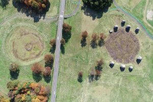
The Manza and Nonakado stone circles are about 50 meters in diameter. They are mostly alike, with their two rings of stones, with rock formations in the form of sundials placed between the outer and inner rings. It is suspected that both circles share the same design image. Furthermore, the center of the stone rings and the sundial-like rock formations are arranged in a straight line. The point where the sun sets on the summer solstice also lies along the extension of that line, so one viewpoint suggests these formations were set up in this way intentionally.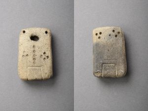
The Doban earthen plates are particularly popular out of the archeological finds. These are items made from clay, with faces, bodies, and so on, represented simply through dots. They have cute facial expressions. They have 1 hole for their mouth, 2 for their eyes, 3 on the right breast, 4 on their left breast, 5 down the center line of their body, and on the back two groups of 3 dots each for a total of 6. Since the numbers 1-6 are shown, this reveals that the people of the time possessed the concept of numbers.
○Isedotai Site (Kitaakita City)
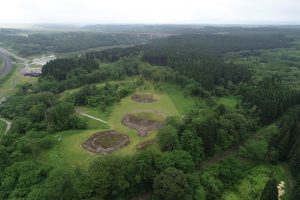
The four stone circles of A, B, C, and D all have different forms, and have gaps in between the times they were built. With four stone circles in one place, this is the most in a single spot in all of Japan. On a flat plateau stretching 700 meters to the north and south, the stone circles were constructed only on the northernmost 200 meters. This is at the point of the plateau from where the Takanosu Basin, as well as the World Natural Heritage Site of the Shirakami Mountains, can be seen. Due to this, it is thought that the construction location was chosen with the view in mind.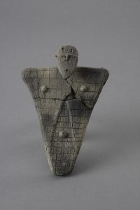
The plate-shaped clay figures are particularly famous out of the archeological finds. They are clay figures with a face, and a latticework pattern on the front of their bodies, with a diagonal line pattern on the back of their bodies. On their face, they have eyebrows, eyes, a nose, and a mouth. They also have two holes passing through their heads. Since other clay figures of the same time period would have something on their heads to represent hair, perhaps something was passed through these two holes in order to represent hair on these plate-shaped clay figures.